CLTKCLT
May 17, 2026 – May 20, 20264 days5,137 flights3,447,327 ADS-B points
Get this printAbout the data
Flights reconstructed from ADS-B, the position signal modern aircraft broadcast to air traffic. Coverage is strongest across North America and Europe, thinner over oceans, polar regions, and parts of Asia and Africa.
Long-haul flights whose paths cross sparsely-covered areas may appear with an unknown origin or destination, because the receiver network loses sight of them mid-ocean. We mark those unknown rather than guess. Every flight is still counted in the totals; the route-by-route breakdown filters to flights with identified endpoints.

Loading flights…
Summary
Total Flights
5,137
Arrivals
2,755
Departures
2,382
Unique Aircraft
1,034
Peak Day Flights
1,518
Avg / Day
1,284
Notable Flights
Shortest
3 NM4 min
From CLT — Charlotte Douglas
N616NN
Longest
2230 NM307 min
From SEA — Seattle–Tacoma
N540UW
Highest
50,475 ft535 NM
From SUS — Spirit of St Louis
N136ZC
Most Active
33
Day Highlights
Each day in EDT time
Busiest Day
May 18, 2026
1518 flights · 784 arr / 734 dep
Quietest Day
May 17, 2026
809 flights · 534 arr / 275 dep
Avg Daily Flights
1,284
across 4 days
| Date | Flights |
|---|---|
| Sun 5/17 | 809 |
| Mon 5/18 | 1518 |
| Tue 5/19 | 1353 |
| Wed 5/20 | 1457 |
Performance
Max Altitude
50,475ft
Avg Altitude
15,511ft
Max Groundspeed
594kts
Avg Groundspeed
298kts
Total Distance
2,645,672NM
Avg Leg Distance
515NM
Avg Leg Duration
90min
Traffic Flow
Arrivals
Departures
Flight Trails
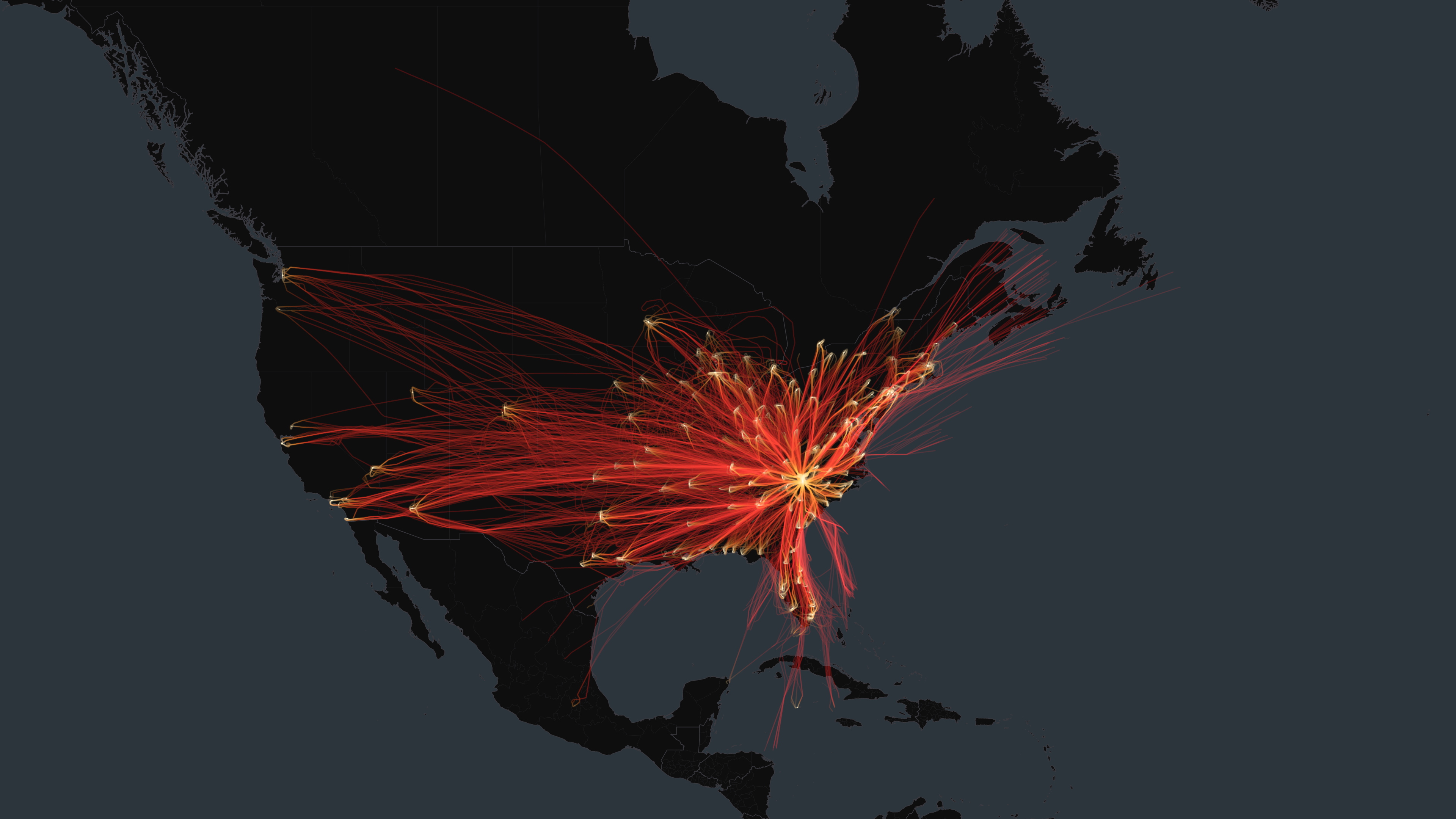
Routes
Arriving from
MCO
Orlando International Airport47
ATL
Hartsfield Jackson Atlanta International Airport45
BNA
Nashville International Airport44
ORD
Chicago O'Hare International Airport43
BOS
General Edward Lawrence Logan International Airport41
LGA
LaGuardia Airport41
CHS
Charleston International Airport37
PHX
Phoenix Sky Harbor International Airport36
ILM
Wilmington International Airport35
MIA
Miami International Airport35
DFW
Dallas Fort Worth International Airport34
GSP
Greenville-Spartanburg International Airport34
PHL
Philadelphia International Airport33
IAD
Washington Dulles International Airport33
RDU
Raleigh-Durham International Airport33
TPA
Tampa International Airport32
DTW
Detroit Metropolitan Wayne County Airport32
CAE
Columbia Metropolitan Airport32
CHA
Chattanooga Metropolitan Airport (Lovell Field)32
GSO
Piedmont Triad International Airport31
Aircraft by Registration Country
United States1018
Canada9
Germany4
United Arab Emirates2
Mexico1
Aircraft
1034 unique aircraft
N661JA
33 flights
N690AE
30 flights
N682AE
29 flights
N656AE
28 flights
N659AE
27 flights
N907AE
27 flights
N939AE
27 flights
N649PP
26 flights
N650AE
26 flights
N686AE
26 flights
N581NN
25 flights
N665BC
25 flights
N932AE
25 flights
N556NN
24 flights
N558NN
24 flights
N647AW
24 flights
N654AE
24 flights
N699AE
24 flights
N660CL
23 flights
N669MB
23 flights
Every flight path above, on a museum-quality aluminum print.