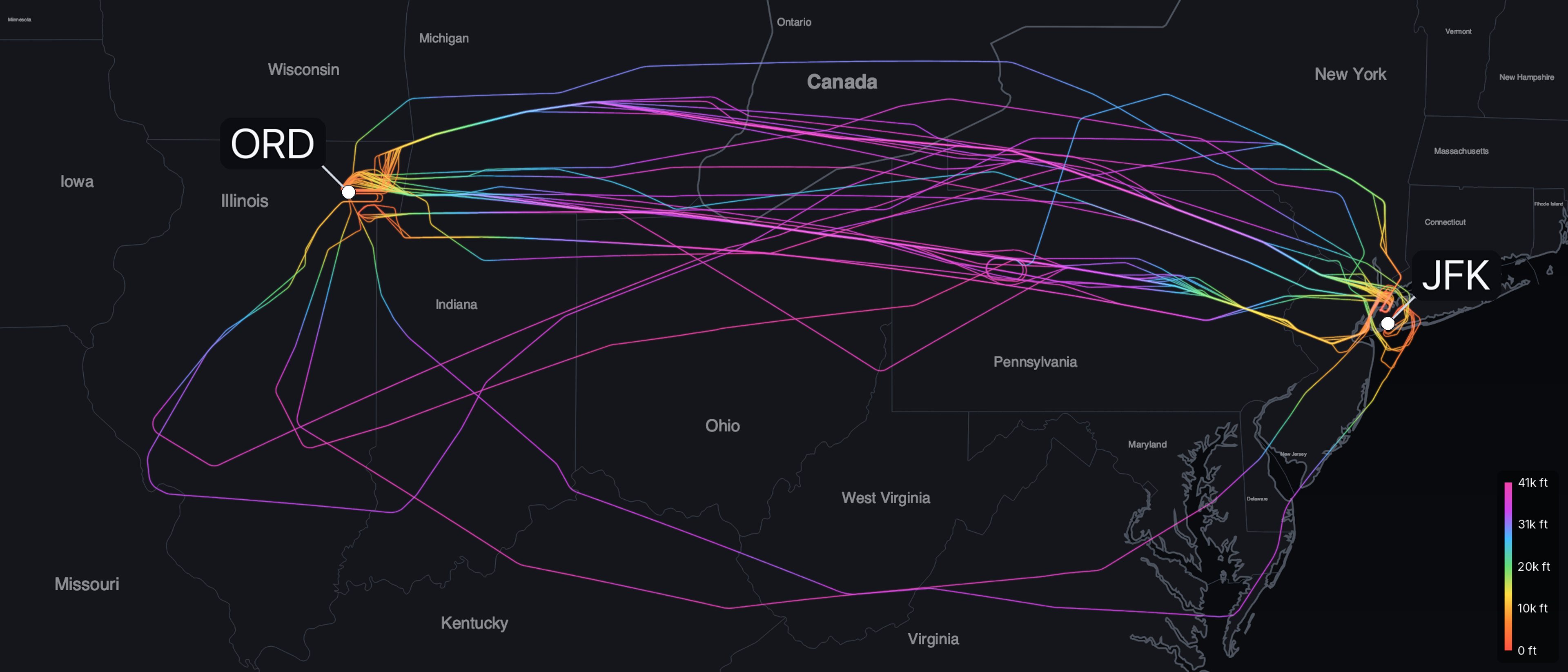
Ask how high a plane flies and most people say 35,000 feet. On June 10, 2026, we tracked 44 flights from Chicago O'Hare to New York. Only four of them cruised at 35,000 feet. The rest leveled off anywhere from 30,000 to 42,000, most of them higher, at 38,000 or 39,000.
35,000 feet is a name for a band, not a single altitude. A jet climbs to reach thin air, because that is where it flies most efficiently. How high any one flight settles inside the band is a trade, struck against the jet's weight, the wind, and its type. The flights we tracked show how.
Why jets climb into thin air
A jet is most efficient when it flies fast. Near the ground, flying fast is expensive, because the dense air pushes back hard. That resistance is drag, and drag grows with both the density of the air and the speed of the jet. Climb, and the air thins. At 35,000 feet it is about a third as dense as it is at sea level.
To stay level, a wing has to hold up the jet's full weight, which it does by deflecting air downward. Thin air gives it less to deflect, so the wing has to move through it faster to make up the difference. That is the trade a jet climbs for. In thin air it flies faster for about the same drag, so it covers more ground for every pound of fuel. The engines add to the gain, because they burn fuel more efficiently in cold, thin air.
Why the climb stops
Thin air is efficient, but the climb still has to stop. The wing already has to fly faster as the air thins. It cannot speed up without limit: near the speed of sound, the air moving over the wing forms shock waves, and drag climbs steeply. So two speeds close on each other as the jet rises. One is the slowest speed that still holds it up. The other is the fastest speed it can safely fly. Where they meet, there is no room left to climb. Pilots call that squeeze the coffin corner, and airliners cruise well below it.
The engines set a second limit. A jet makes thrust from the air it draws in, and thin air gives it less to work with, so its power falls with height. The jet climbs until the next thousand feet would save less fuel than it costs to hold. That is where it levels off. For most airliners, that is somewhere in the thirty-thousands.
One flight from O'Hare to New York
Here is one of the flights we tracked. It broadcast its position the whole way across 680 nautical miles. (A nautical mile is about 1.15 of the miles on a road sign.) The chart plots its altitude against the distance it flew.
The climb is short and steep. This flight reached its cruising altitude of 38,000 feet after 137 nautical miles, a fifth of the way to New York. Climbing burns more fuel per mile than any other part of the flight, so the jet pays that cost early. Then it holds 38,000 feet for hundreds of miles, its engines eased back from climb power to a steady cruise.
The descent is longer than the climb. The jet started down 216 nautical miles from New York, a little under a third of the route, and gave the height back in one long glide with the engines near idle. The climb took 137 miles. The descent took 216.
Why no two flights pick the same altitude
That flight held 38,000 feet. The next one chose something else. The best altitude depends on how heavy the jet is, which way the wind blows up high, and what type it is. A heavy jet cruises lower, because its wing needs more air to carry the extra weight. As it burns fuel off and lightens, it can climb higher. A tailwind a few thousand feet up can be worth more than the fuel it costs to climb into it. Two different types reach their best trade at different heights.
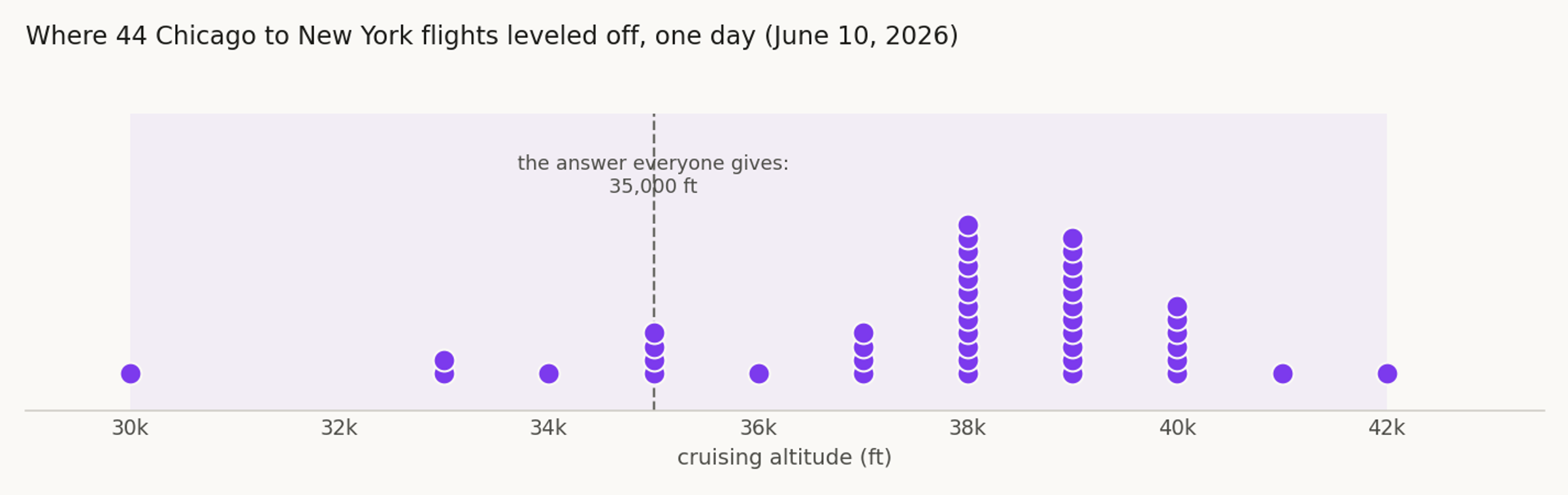
The 44 flights we tracked that day spread out along exactly those lines. They leveled off from 30,000 to 42,000 feet. Only four held 35,000. Most were higher, at 38,000 or 39,000. The route and the day were the same for all of them, and the spread was 12,000 feet.
What the number actually measures
One caveat, because every altitude here rests on it. The number an aircraft broadcasts is not its height above the ground. It is a pressure reading, converted to a height. Above 18,000 feet, every aircraft sets its altimeter to the same standard pressure, so they all measure from one shared baseline. That keeps them stacked a safe distance apart even where the real air pressure drifts. Pilots call it pressure altitude. It is the number air traffic control separates traffic by, and the number our tracks record. When the map reads 38,000 feet, that is the level the aircraft was assigned and held.
The shape on the wall
You cannot see any of this from a window seat. It shows up when you take a whole flight, plot its altitude against the distance it covered, and read the shape: the steep climb, the long cruise, the slow descent. Those shapes, one real flight at a time, are what we turn into the prints we make. The next time someone tells you planes fly at 35,000 feet, you can tell them which flight, and how high it actually went.
Sources
Flight tracks and altitudes: our own ADS-B render of 49 Chicago to New York flights on June 10, 2026. We tracked 44 of them cleanly from airport to airport, and took each flight's cruising altitude as the level it held longest. We chose the route because it stays over land, where ground receivers are dense, so the tracks run unbroken from climb to descent. Air density figures: the U.S. Standard Atmosphere. The standard-pressure setting and the 18,000-foot transition: the FAA. For what the signal itself is, see what ADS-B actually is; for why the ground track bends, see why flight paths aren't straight lines.