Look at almost any flight on a tracking map and the line connecting departure to arrival is never quite straight. It bows toward the pole, steps sideways around a waypoint, wanders to skirt a storm, then bends again on the approach. The straight line you might expect, ruler-laid from one airport to the next, almost never appears. That is not inefficiency or sloppy flying. A flight path is the record of several forces resolving at once, and each one pulls the route away from the straight line.
The map is the first illusion
The most common reason a route looks bent is that the map is flat and the planet is not. The shortest distance between two points on a globe is a great-circle arc, the line you would trace by pulling a string taut across a physical model of the Earth. Project that arc onto a flat Mercator map, the kind used by most tracking sites, and it appears to curve, usually bowing toward the nearer pole.
This is why a flight from the US East Coast to Japan looks like it detours far north over Alaska and the Arctic rather than heading due west. On the globe, that northern arc is the direct path. KJFK to RJTT, New York to Tokyo, follows a great circle that climbs to high latitude because that is genuinely the shorter way around a sphere. The straight line on the flat map would be longer in the real world. The curve is the efficient choice; the map only makes it look like a detour.
The effect grows with distance and with how far the cities sit from the equator. A flight from the US West Coast to Europe arcs up over eastern Canada and Greenland for the same reason. The longer the route and the higher the latitudes it crosses, the more pronounced the bend on a flat map, even though the aircraft is flying the straightest line available to it.
A road network in the sky
Even on the great circle, aircraft rarely fly a single clean arc, because the airspace they cross is organized into published routes. For most of aviation's history, traffic followed airways: defined corridors strung between radio navigation aids and, later, named GPS waypoints. In the United States these include the low-altitude Victor airways and the high-altitude jet routes, alongside the newer RNAV Q and T routes. A flight plan is filed as a sequence of these segments, so the aircraft tracks from waypoint to waypoint rather than pointing straight at the destination.
The segments connect at angles, which is why a cruise track often looks like a series of long straight legs joined by small course changes rather than one continuous line. Airspace is moving toward more flexible "free route" operations in some regions, letting aircraft plan more direct paths, but a great deal of the system still runs on this fixed lattice of corridors, and the lattice was never laid out in straight lines to every city pair.
Departures and arrivals are choreography
The bends are most pronounced near the ground. An aircraft leaving a busy airport does not climb straight out on course. It follows a standard instrument departure, a published procedure with specific headings and altitude restrictions designed to separate departing traffic from arrivals, keep aircraft clear of terrain, and route noise away from populated areas. Arrivals work the same way in reverse, funneling traffic down a standard arrival procedure into an orderly stream.
On top of those procedures, controllers issue vectors: direct heading instructions that turn an aircraft left or right to maintain separation, sequence it behind other traffic, or slot it onto final approach. A landing aircraft is often walked through a downwind, base, and final pattern, each leg a deliberate turn. None of that is on the flight-planned route; it is added live, and it shows up on the track as the tight hooks and dog-legs near the airport.
When arrivals stack up faster than the runway can take them, controllers send the extra aircraft to wait their turn in a holding pattern, a racetrack flown over a fixed point until a gap opens. Those loops are some of the most recognizable shapes in a flight track.
Flying around the weather
Weather rewrites routes in real time. Thunderstorms carry severe turbulence, hail, and lightning, and crews will not fly through a developing cell. When a line of storms sits across the planned track, aircraft deviate around it, sometimes by many miles, then rejoin the route on the far side. Those deviations appear as smooth bulges or sudden jogs in an otherwise steady cruise line.
Other conditions bend routes too. Areas of forecast turbulence get avoided for passenger comfort and safety, and volcanic ash, which can damage engines, closes whole swaths of airspace and forces long reroutes. The track records the decision the crew and controllers actually made against the conditions of that day, not the plan filed before departure.
Riding the wind
At cruising altitude the air is moving, often fast. The jet streams are narrow bands of strong wind in the upper atmosphere where speeds can exceed 100 knots, and an airline will plan a route to use them rather than fight them. An eastbound flight across an ocean will steer toward a favorable tailwind even if that means flying extra distance, because the wind savings outweigh the longer path. A westbound flight does the opposite, dodging the same jet stream to avoid a brutal headwind.
The North Atlantic shows this clearly. The busy corridor between North America and Europe is managed with the North Atlantic Tracks, a set of parallel routes that are repositioned and republished twice a day to match the day's winds. The eastbound and westbound track systems sit in different places, and they move from one day to the next. Two flights between the same two cities on consecutive days can follow noticeably different paths, because the wind underneath them changed. The systems are also timed to the flow of traffic, with the main eastbound tracks active overnight and the westbound tracks during the day, so the corridor an aircraft is handed depends on when it crosses as much as where it is going.
Where you simply can't go
Finally, some airspace is closed. Prohibited and restricted areas, active military operating zones, and conflict regions are off limits or require special permission, and routes are planned to go around them. International flights also depend on overflight rights negotiated between countries, which can rule out the most direct path entirely.
Long overwater flights add another constraint. Twin-engine aircraft operate under ETOPS rules that keep them within a set flying time of a suitable diversion airport in case an engine fails. On routes far from land, that requirement bends the path toward the chain of airports that can serve as diversions, rather than letting the aircraft take the shortest line across open ocean.
What the track really shows
Put all of this together and a flight path stops looking like a failure to fly straight and starts looking like what it is: a negotiated line. It reflects the curvature of the planet, the fixed geometry of the airway system, the live instructions of air traffic control, the weather on the day, the wind at altitude, and the politics of whose airspace lies between origin and destination.
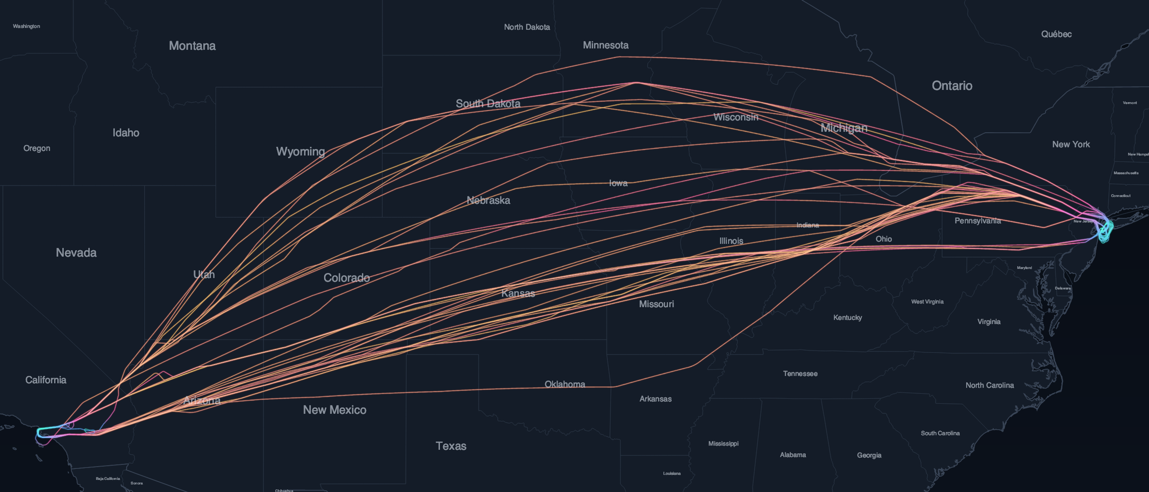
The image at the top of this article shows exactly that. On February 18, 2026, 38 tracked flights connected Los Angeles and New York, and no two followed the same line. Almost every one bowed north of the direct route, and together they averaged 2,277 nautical miles against a great-circle distance of 2,146. The straight line is the one path none of them flew.
That is also what makes a recorded flight path worth looking at. The bends are not noise. Each one is a decision, and the finished line is the trace those decisions left behind. The same broadcast data that lets a controller manage the traffic, the ADS-B signal every aircraft transmits, is what preserves that exact path afterward, which is the raw material behind the flight-path prints we make at SkyPath.