MIAKMIA
January 4, 2025 – April 13, 2025100 days4,795 flights2,455,132 ADS-B points
Get this printAbout the data
Flights reconstructed from ADS-B, the position signal modern aircraft broadcast to air traffic. Coverage is strongest across North America and Europe, thinner over oceans, polar regions, and parts of Asia and Africa.
Long-haul flights whose paths cross sparsely-covered areas may appear with an unknown origin or destination, because the receiver network loses sight of them mid-ocean. We mark those unknown rather than guess. Every flight is still counted in the totals; the route-by-route breakdown filters to flights with identified endpoints.

Loading flights…
Summary
Total Flights
4,795
Arrivals
3,142
Departures
1,653
Unique Aircraft
2,183
Peak Day Flights
305
Avg / Day
48
Notable Flights
Shortest
5 NM3 min
From MIA — Miami
N177QS
Longest
3111 NM419 min
N486MC
Highest
48,575 ft1100 NM
To HPN — Westchester County
N504AC
Most Active
30flights
Day Highlights
Each day in EST time
Busiest Day
Apr 5, 2025
305 flights · 290 arr / 15 dep
Quietest Day
Jan 19, 2025
1 flight · 0 arr / 1 dep
Avg Daily Flights
48
across 100 days
| Date | Flights |
|---|---|
| Sat 1/4 | 64 |
| Sun 1/5 | 47 |
| Mon 1/6 | 8 |
| Tue 1/7 | 5 |
| Wed 1/8 | 14 |
| Thu 1/9 | 16 |
| Fri 1/10 | 4 |
| Sat 1/11 | 1 |
| Sun 1/12 | 65 |
| Mon 1/13 | 3 |
| Tue 1/14 | 10 |
| Wed 1/15 | 37 |
| Thu 1/16 | 28 |
| Fri 1/17 | 15 |
| Sat 1/18 | 2 |
| Sun 1/19 | 1 |
| Mon 1/20 | 49 |
| Tue 1/21 | 30 |
| Wed 1/22 | 21 |
| Thu 1/23 | 27 |
| Fri 1/24 | 31 |
| Sat 1/25 | 97 |
| Sun 1/26 | 109 |
| Mon 1/27 | 40 |
| Tue 1/28 | 56 |
| Wed 1/29 | 49 |
| Thu 1/30 | 103 |
| Fri 1/31 | 19 |
| Sat 2/1 | 5 |
| Sun 2/2 | 13 |
| Mon 2/3 | 14 |
| Tue 2/4 | 14 |
| Thu 2/6 | 13 |
| Fri 2/7 | 43 |
| Sat 2/8 | 50 |
| Sun 2/9 | 43 |
| Mon 2/10 | 49 |
| Tue 2/11 | 31 |
| Wed 2/12 | 11 |
| Thu 2/13 | 49 |
| Fri 2/14 | 63 |
| Sat 2/15 | 28 |
| Sun 2/16 | 6 |
| Mon 2/17 | 5 |
| Tue 2/18 | 36 |
| Wed 2/19 | 20 |
| Thu 2/20 | 10 |
| Fri 2/21 | 42 |
| Sat 2/22 | 68 |
| Sun 2/23 | 61 |
| Mon 2/24 | 168 |
| Tue 2/25 | 2 |
| Wed 2/26 | 4 |
| Thu 2/27 | 61 |
| Fri 2/28 | 18 |
| Sat 3/1 | 7 |
| Sun 3/2 | 3 |
| Mon 3/3 | 7 |
| Tue 3/4 | 5 |
| Wed 3/5 | 11 |
| Thu 3/6 | 3 |
| Fri 3/7 | 38 |
| Sat 3/8 | 8 |
| Sun 3/9 | 4 |
| Mon 3/10 | 3 |
| Tue 3/11 | 71 |
| Wed 3/12 | 167 |
| Thu 3/13 | 107 |
| Fri 3/14 | 16 |
| Sat 3/15 | 9 |
| Sun 3/16 | 4 |
| Mon 3/17 | 10 |
| Tue 3/18 | 15 |
| Wed 3/19 | 40 |
| Thu 3/20 | 211 |
| Fri 3/21 | 3 |
| Sat 3/22 | 42 |
| Sun 3/23 | 94 |
| Mon 3/24 | 19 |
| Tue 3/25 | 57 |
| Wed 3/26 | 12 |
| Thu 3/27 | 120 |
| Fri 3/28 | 39 |
| Sat 3/29 | 10 |
| Sun 3/30 | 8 |
| Mon 3/31 | 69 |
| Tue 4/1 | 5 |
| Wed 4/2 | 3 |
| Thu 4/3 | 21 |
| Fri 4/4 | 170 |
| Sat 4/5 | 305 |
| Sun 4/6 | 230 |
| Mon 4/7 | 177 |
| Tue 4/8 | 23 |
| Wed 4/9 | 90 |
| Thu 4/10 | 260 |
| Fri 4/11 | 202 |
| Sat 4/12 | 24 |
| Sun 4/13 | 195 |
Performance
Max Altitude
48,575ft
Avg Altitude
21,689ft
Max Groundspeed
642kts
Avg Groundspeed
353kts
Total Distance
3,538,682NM
Avg Leg Distance
738NM
Avg Leg Duration
110min
Traffic Flow
Arrivals
Departures
Flight Trails
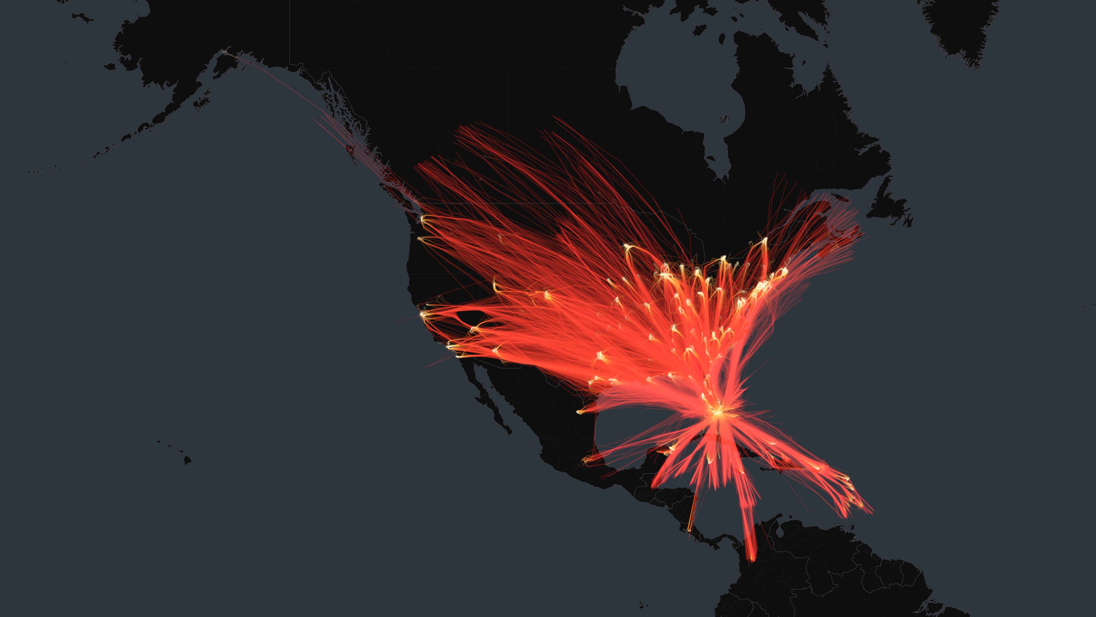
Routes
Arriving from
ATL
Hartsfield Jackson Atlanta International Airport96
TPA
Tampa International Airport69
DFW
Dallas Fort Worth International Airport64
LAX
Los Angeles International Airport64
DEN
Denver International Airport51
SJU
Luis Munoz Marin International Airport48
JFK
John F. Kennedy International Airport44
MCO
Orlando International Airport38
PHX
Phoenix Sky Harbor International Airport37
LAS
Harry Reid International Airport35
IAH
George Bush Intercontinental Airport34
CVG
Cincinnati Northern Kentucky International Airport34
ORD
Chicago O'Hare International Airport33
PHL
Philadelphia International Airport32
LGA
LaGuardia Airport31
MSY
Louis Armstrong New Orleans International Airport29
SLC
Salt Lake City International Airport25
TLH
Tallahassee International Airport24
BOS
General Edward Lawrence Logan International Airport23
DCA
Ronald Reagan Washington National Airport23
Aircraft by Registration Country
United States1795
Canada101
Unknown42
Panama38
Mexico35
Brazil18
United Kingdom17
Türkiye16
Germany9
Slovakia9
Aircraft
2183 unique aircraft
N805WA
30 flights
N334QT
22 flights
N330QT
21 flights
N702FE
20 flights
N331QT
19 flights
N335QT
19 flights
N336QT
18 flights
N642VA
18 flights
N285NN
14 flights
N566NC
14 flights
N287NN
13 flights
N9016
13 flights
N207AN
13 flights
N732US
13 flights
N705UW
12 flights
N957XV
11 flights
0C4395ADS-B hex code — tail number not resolved
11 flights
N563NC
11 flights
N649GT
11 flights
N1409A
11 flights
Every flight path above, on a museum-quality aluminum print.